
Ruvuma Region topographic map
Interactive map
Click on the map to display elevation.
Ruvuma Region
Ruvuma Region is located in the Southern Highlands, which range between 300 and 2000 meters above sea level. Lake Nyasa, which is located in the Western arm of the Great Rift Valley, covers the western portion of the area. The Matengo Mountains ranges, which reach heights of up to 2000 meters, are to the east of the Rift Valley. In a similar vein, the Lukumburu Mountains, which can reach an elevation of 2000 meters above sea level, are located to the north. The Ruvuma River cuts across the lower plains in the region's south. The region has diverse topology. While the Lukumburu and Matengo mountains' northern and western portions climb to a height of 2,000 meters above sea level, the region's eastern lowlands are only 300 meters above sea level.
About this map
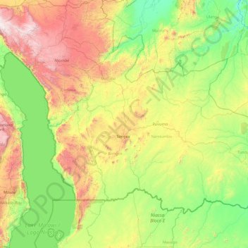
Name: Ruvuma Region topographic map, elevation, terrain.
Location: Ruvuma Region, Southern Highlands Zone, Tanzania (-11.76125 34.57244 -9.25038 38.11504)
Average elevation: 829 m
Minimum elevation: 216 m
Maximum elevation: 2,916 m
Other topographic maps
Click on a map to view its topography, its elevation and its terrain.
Kilimanjaro
Mount Kilimanjaro (/ˌkɪlɪmənˈdʒɑːroʊ/) is a dormant volcano in Tanzania. It is the highest mountain in Africa and the highest free-standing mountain above sea level in the world: 5,895 m (19,341 ft) above sea level and 4,900 m (16,100 ft) above its plateau base. It is also the highest volcano in the…
Average elevation: 1,537 m
Mbeya
Mbeya is situated at an altitude of 1,700 metres (5,500 ft), and sprawls through a narrow highland valley surrounded by a bowl of high mountains. The main language is colloquial Swahili, and the English language is extensively taught in schools.
Average elevation: 1,817 m
Bukoba
Bukoba has an upland tropical monsoon climate (Köppen Amb, because every month has a normal mean temperature of between 18 °C and 22 °C) although it is milder than most climates with that classification due to its altitude. It can sometimes get cool especially in the evenings during the two rainy seasons,…
Average elevation: 1,177 m
Kilimanjaro
Mount Kilimanjaro (/ˌkɪlɪmənˈdʒɑːroʊ/) is a dormant volcano in Tanzania. It is the highest mountain in Africa and the highest free-standing mountain above sea level in the world, at 5,895 m (19,341 ft) above sea level and 4,900 m (16,100 ft) above its plateau base. It is also the highest volcano in…
Average elevation: 1,537 m
Lake Chala
Lake Chala's average annual rainfall is about 565 millimetres (22.2 in). The lake surface has an average annual evaporation of near 1,735 millimetres (68.3 in). Approximately 80 percent of the lake's inflow comes from groundwater, which is derived mostly from rainfall in the montane forest zone of Mount…
Average elevation: 900 m
Kilimanjaro
Mount Kilimanjaro (/ˌkɪlɪmənˈdʒɑːroʊ/) is a dormant volcano in Tanzania. It is the highest mountain in Africa and the highest free-standing mountains above sea level in the world, at 5,895 m (19,341 ft) above sea level and 4,900 m (16,100 ft) above its plateau base. It is also the highest volcano in…
Average elevation: 1,537 m
Kilimanjaro
Mount Kilimanjaro (/ˌkɪlɪmənˈdʒɑːroʊ/) is a dormant volcano in Tanzania. It is the highest mountain in Africa and the highest free-standing mountain above sea level in the world: 5,895 m (19,341 ft) above sea level and 4,900 m (16,100 ft) above its plateau base. It is also the highest volcano in the…
Average elevation: 1,537 m
Kilimanjaro
Mount Kilimanjaro (/ˌkɪlɪmənˈdʒɑːroʊ/) is a dormant volcano in Tanzania. It is the highest mountain in Africa and the highest free-standing mountain above sea level in the world, situated at 5,895 m (19,341 ft) above sea level and 4,900 m (16,100 ft) above its plateau base. It is also the highest…
Average elevation: 1,537 m
Kilimanjaro
Kilimanjaro is the fourth most topographically prominent peak on Earth. It is part of Kilimanjaro National Park and is a major hiking and climbing destination. Because of its shrinking glaciers and ice fields, which are projected to disappear between 2025 and 2035, it has been the subject of many scientific…
Average elevation: 1,537 m
Mbeya
Mbeya is situated at an altitude of 1,700 metres (5,500 ft), and sprawls through a narrow highland valley surrounded by a bowl of high mountains. The main language is colloquial Swahili, and the English language is extensively taught in schools.
Average elevation: 1,817 m
Dodoma
The official capital since 1996, Dodoma was envisaged as the first non-monumental capital city as opposed to the monumentality and hierarchy of other planned capital cities such as Abuja, Yamoussoukro, Brasília and Washington, D.C. It rejected geometrical forms such as grid iron and radial plans as…
Average elevation: 1,143 m