
Yangyang-gun topographic map
Interactive map
Click on the map to display elevation.
About this map
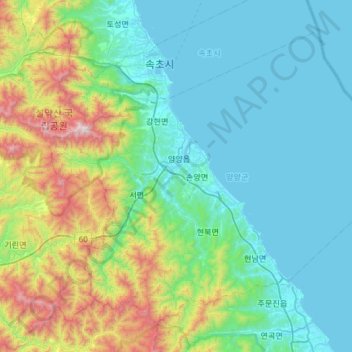
Name: Yangyang-gun topographic map, elevation, terrain.
Location: Yangyang-gun, Gangwon-do, South Korea (37.86186 128.40405 38.25083 128.99769)
Average elevation: 328 m
Minimum elevation: -2 m
Maximum elevation: 1,679 m
Other topographic maps
Click on a map to view its topography, its elevation and its terrain.
Gangwon
South Korea > Gangwon-do > Chuncheon-si > Bongui-dong
Gangwon, 모수물길, Bongui-dong, Chuncheon-si, Gangwon-do, 24267, South Korea
Average elevation: 95 m
Aesan-ri
South Korea > Gangwon-do > Aesan-ri
Aesan-ri, Jeongseon-gun, Gangwon-do, South Korea
Average elevation: 449 m