
Manche topographic map
Interactive map
Click on the map to display elevation.
About this map
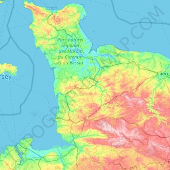
Name: Manche topographic map, elevation, terrain.
Location: Manche, Normandy, Metropolitan France, France (48.45580 -1.95506 49.72801 -0.73484)
Average elevation: 63 m
Minimum elevation: -2 m
Maximum elevation: 362 m
Other topographic maps
Click on a map to view its topography, its elevation and its terrain.
Auverne
France > Normandy > Orne > Juvigny-Val-d'Andaine > La Baroche-sous-Lucé
Average elevation: 152 m
Saint-Martin-de-Fontenay
France > Normandy > Calvados > Saint-Martin-de-Fontenay > Saint-Martin-de-Fontenay
Average elevation: 48 m
Cerisy-la-Salle
France > Normandy > Manche > Cerisy-la-Salle > Cerisy-la-Salle
Average elevation: 108 m
La Pâture aux Lièvres
France > Normandy > La Ferrière-Bochard > La Pâture aux Lièvres
Average elevation: 171 m