
Thank you for supporting this site ❤️
Make a donation
Make a donation
Gear up for your next adventure:
As an Amazon Associate, this site earns from qualifying purchases at no extra cost to you.
Snowdon topographic map
Click on the map to display elevation.
Thank you for supporting this site ❤️
Make a donation
Make a donation
Gear up for your next adventure:
As an Amazon Associate, this site earns from qualifying purchases at no extra cost to you.
About this map
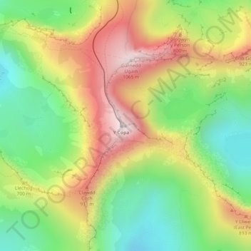
Name: Snowdon topographic map, elevation, terrain.
Location: Snowdon, Bangor, Gwynedd, Wales, LL55 4UL, United Kingdom (53.06843 -4.07623 53.06853 -4.07613)
Average elevation: 692 m
Minimum elevation: 390 m
Maximum elevation: 1,061 m
Wales trails, hiking, mountain biking, running and outdoor activities
Thank you for supporting this site ❤️
Make a donation
Make a donation
Gear up for your next adventure:
As an Amazon Associate, this site earns from qualifying purchases at no extra cost to you.