
Central District topographic map
Interactive map
Click on the map to display elevation.
About this map
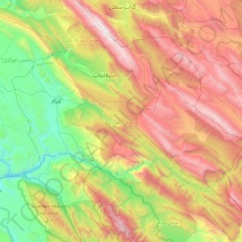
Name: Central District topographic map, elevation, terrain.
Average elevation: 1,721 m
Minimum elevation: 544 m
Maximum elevation: 3,480 m
Other topographic maps
Click on a map to view its topography, its elevation and its terrain.
Bi Bi Hakimeh
Iran > Kohgiluye and Buyer Ahmad Province > Gachsaran County > دهستان بی بی حکیمه
Bi Bi Hakimeh, دهستان بی بی حکیمه, بخش مرکزی, Gachsaran County, Kohgiluye and Buyer Ahmad Province, Iran
Average elevation: 437 m
Boyer Ahmad
Iran > Kohgiluye and Buyer Ahmad Province > Buyerahmad County > Yasuj
Boyer Ahmad, ناحیه ۱, Yasuj, بخش مرکزی بویراحمد, Buyerahmad County, Kohgiluye and Buyer Ahmad Province, Iran
Average elevation: 1,845 m
Yasuj
Iran > Kohgiluye and Buyer Ahmad Province > Buyerahmad County
Yasuj, بخش مرکزی بویراحمد, Buyerahmad County, Kohgiluye and Buyer Ahmad Province, 75917-78449, Iran
Average elevation: 1,860 m
Abadeh
Iran > Kohgiluye and Buyer Ahmad Province > Buyerahmad County > دهستان لوداب
Abadeh, دهستان لوداب, بخش لوداب, Buyerahmad County, Kohgiluye and Buyer Ahmad Province, Iran
Average elevation: 1,548 m
Yasuj
Iran > Kohgiluye and Buyer Ahmad Province > Buyerahmad County > Yasuj
Yasuj, بخش مرکزی شهرستان بویراحمد, Buyerahmad County, Kohgiluye and Buyer Ahmad Province, 7591778449, Iran
Average elevation: 2,335 m
Dogonbadan
Iran > Kohgiluye and Buyer Ahmad Province > Gachsaran County > دهستان لیشتر
Dogonbadan, دهستان لیشتر, بخش مرکزی, Gachsaran County, Kohgiluye and Buyer Ahmad Province, Iran
Average elevation: 774 m
Dena
Iran > Kohgiluye and Buyer Ahmad Province > Dena County > دهستان دنا
Dena, دهستان دنا, بخش مرکزی دنا, Dena County, Kohgiluye and Buyer Ahmad Province, Iran
Average elevation: 3,896 m