
Volcán Nevado del Ruiz topographic map
Interactive map
Click on the map to display elevation.
Volcán Nevado del Ruiz
The summit of the volcano has steep slopes inclining from 20 to 30 degrees. At lower elevations, the slopes become less steep; their inclination is about 10 degrees. From there on, foothills stretch almost to the edge of the Magdalena River, north of the volcano and the Cauca River to the west. On the two major sides of the summit, headwalls show where past rock avalanches occurred. At times, ice on the summit has melted, generating devastating lahars, including the continent's deadliest eruption in 1985. On the volcano's southwest flank is the pyroclastic cone La Olleta, which is not currently active, but may have erupted in historical times.
About this map
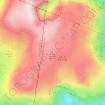
Name: Volcán Nevado del Ruiz topographic map, elevation, terrain.
Average elevation: 5,119 m
Minimum elevation: 4,738 m
Maximum elevation: 5,286 m
Other topographic maps
Click on a map to view its topography, its elevation and its terrain.
Líbano
Líbano is located in the Cordillera Central, east of Nevado del Ruiz. The town is at an altitude of 1,565 metres (5,135 ft) above sea level, putting it in the tierra templada, or temperate zone, of Colombia. The area is hilly and heavily forested where it is not used for agriculture. Agriculture in the area…
Average elevation: 1,687 m
Ibagué
Ibagué features a tropical rainforest climate under the Köppen climate classification, albeit a relatively cooler version of the climate due to the high altitude. Although the city does experience noticeably drier conditions during and around the months of January and July, the city has no true dry season…
Average elevation: 1,907 m