
Bisbee topographic map
Interactive map
Click on the map to display elevation.
About this map
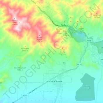
Name: Bisbee topographic map, elevation, terrain.
Location: Bisbee, Cochise County, Arizona, United States (31.37749 -109.95331 31.46222 -109.86746)
Average elevation: 1,676 m
Minimum elevation: 1,436 m
Maximum elevation: 2,238 m
Other topographic maps
Click on a map to view its topography, its elevation and its terrain.
Chiricahua National Monument
United States > Arizona > Cochise County
Chiricahua National Monument, Cochise County, Arizona, United States
Average elevation: 1,861 m
Willcox
United States > Arizona > Cochise County
Willcox, Cochise County, Arizona, 85643, United States
Average elevation: 1,274 m
Bakerville
United States > Arizona > Cochise County > Bisbee > Warren
Bakerville, Warren, Bisbee, Cochise County, Arizona, 85603, United States
Average elevation: 1,579 m
Cathedral Rock
United States > Arizona > Cochise County
Cathedral Rock, Cochise County, Arizona, United States
Average elevation: 1,774 m
Douglas
United States > Arizona > Cochise County > Douglas
Douglas, Cochise County, Arizona, United States
Average elevation: 1,265 m
Sierra Vista
United States > Arizona > Cochise County
Sierra Vista, Cochise County, Arizona, United States
Average elevation: 1,507 m
Portal
United States > Arizona > Cochise County > Portal
Portal, Cochise County, Arizona, United States
Average elevation: 1,523 m
Whetstone
United States > Arizona > Cochise County
Whetstone, Cochise County, Arizona, United States
Average elevation: 1,324 m