
El Gilf El Kebir Plateau topographic map
Interactive map
Click on the map to display elevation.
About this map
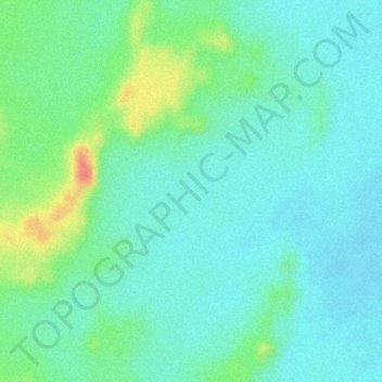
Name: El Gilf El Kebir Plateau topographic map, elevation, terrain.
Location: El Gilf El Kebir Plateau, New Valley Governorate, Egypt (23.38046 26.08927 23.40046 26.10927)
Average elevation: 1,037 m
Minimum elevation: 1,017 m
Maximum elevation: 1,088 m
Other topographic maps
Click on a map to view its topography, its elevation and its terrain.
Rashida
Egypt > New Valley Governorate > Rashida
Rashida, New Valley Governorate, Egypt
Average elevation: 101 m
El Dakhla Oasis
Egypt > New Valley Governorate > El Dakhla Oasis
El Dakhla Oasis, New Valley Governorate, Egypt
Average elevation: 205 m
Al-Farafra
Egypt > New Valley Governorate > Al-Farafra
Al-Farafra, New Valley Governorate, Egypt
Average elevation: 73 m
Al Izziyah
Egypt > New Valley Governorate > Al Izziyah
Al Izziyah, New Valley Governorate, Egypt
Average elevation: 68 m
Aulad Salama
Egypt > New Valley Governorate > Aulad Salama
Aulad Salama, New Valley Governorate, Egypt
Average elevation: 72 m
Dayr al Abyad
Egypt > New Valley Governorate
Dayr al Abyad, New Valley Governorate, Egypt
Average elevation: 137 m
Hawd Dandarah
Egypt > New Valley Governorate > Al Ashraf al Bahriyah
Hawd Dandarah, Al Ashraf al Bahriyah, New Valley Governorate, Egypt
Average elevation: 74 m