
Lefkada topographic map
Interactive map
Click on the map to display elevation.
About this map
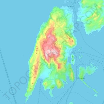
Name: Lefkada topographic map, elevation, terrain.
Average elevation: 111 m
Minimum elevation: -2 m
Maximum elevation: 1,160 m
Other topographic maps
Click on a map to view its topography, its elevation and its terrain.
Municipal Unit of Lefkada
Greece > Peloponnese, Western Greece and the Ionian > Lefkada Regional Unit > Municipal Unit of Lefkada
Municipal Unit of Lefkada, Δήμος Λευκάδας, Lefkada Regional Unit, Ioanian Islands, Peloponnese, Western Greece and the Ionian, 311 00, Greece
Average elevation: 198 m
Katomeri
Greece > Peloponnese, Western Greece and the Ionian > Lefkada Regional Unit > Katomeri
Katomeri, Δήμος Μεγανησίου, Lefkada Regional Unit, Ioanian Islands, Peloponnese, Western Greece and the Ionian, 310 83, Greece
Average elevation: 24 m
Municipal Unit of Apollonioi
Greece > Peloponnese, Western Greece and the Ionian > Lefkada Regional Unit > Municipal Unit of Apollonioi
Municipal Unit of Apollonioi, Δήμος Λευκάδας, Lefkada Regional Unit, Ioanian Islands, Peloponnese, Western Greece and the Ionian, Greece
Average elevation: 182 m