
Newport County topographic map
Interactive map
Click on the map to display elevation.
About this map
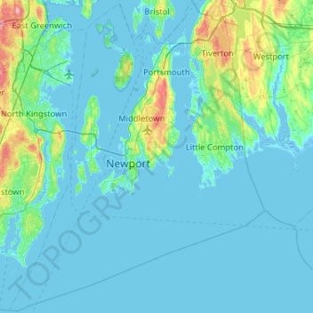
Name: Newport County topographic map, elevation, terrain.
Location: Newport County, Rhode Island, United States (41.30736 -71.50944 41.69050 -71.08857)
Average elevation: 14 m
Minimum elevation: -7 m
Maximum elevation: 130 m
The county consists of Aquidneck Island, Conanicut Island, Prudence Island, and the easternmost portion of the state on the mainland. The highest point in the county is Pocasset Hill, 320 feet (98 m) above sea level, located in Tiverton. The lowest elevation is at sea level.
Other topographic maps
Click on a map to view its topography, its elevation and its terrain.
Anthony
United States > Rhode Island > Kent County > Coventry
Anthony, Coventry, Kent County, Rhode Island, 02816, United States
Average elevation: 71 m
Hope Valley
United States > Rhode Island > South County > Hopkinton
Hope Valley, Hopkinton, South County, Rhode Island, 02832, United States
Average elevation: 54 m
Narragansett
United States > Rhode Island > South County
Narragansett, South County, Rhode Island, 02882, United States
Average elevation: 12 m
North Kingstown
United States > Rhode Island > South County
North Kingstown, South County, Rhode Island, United States
Average elevation: 35 m
South County
South County, Rhode Island, United States
Average elevation: 30 m
Barrington
United States > Rhode Island > Bristol County
Barrington, Bristol County, Rhode Island, 02806, United States
Average elevation: 4 m
Smithfield
United States > Rhode Island > Providence County
Smithfield, Providence County, Rhode Island, United States
Average elevation: 107 m
East Greenwich
United States > Rhode Island > Kent County
East Greenwich, Kent County, Rhode Island, 02818, United States
Average elevation: 21 m
Ashaway
United States > Rhode Island > South County > Hopkinton > Ashaway
Ashaway, Hopkinton, South County, Rhode Island, 02804, United States
Average elevation: 31 m
Scituate
United States > Rhode Island > Providence County
Scituate, Providence County, Rhode Island, United States
Average elevation: 124 m
Charlestown
United States > Rhode Island > South County
Charlestown, South County, Rhode Island, 02813, United States
Average elevation: 22 m
Westerly
United States > Rhode Island > Washington County
Westerly, Washington County, Rhode Island, 02808, United States
Average elevation: 19 m
Portsmouth
United States > Rhode Island > Newport County
Portsmouth, Newport County, Rhode Island, United States
Average elevation: 19 m
Fort Wetherill
United States > Rhode Island > Newport County > Jamestown
Fort Wetherill, Highland Drive, Jamestown, Newport County, Rhode Island, 02835, United States
Average elevation: 4 m
Ell Pond
United States > Rhode Island > South County > Hopkinton
Ell Pond, Hopkinton, South County, Rhode Island, United States
Average elevation: 105 m
East Providence
United States > Rhode Island > Providence County
East Providence, Providence County, Rhode Island, United States
Average elevation: 12 m
Weekapaug
United States > Rhode Island > South County > Westerly
Weekapaug, Westerly, South County, Rhode Island, United States
Average elevation: 8 m
Long Pond
United States > Rhode Island > South County > New Shoreham
Long Pond, New Shoreham, South County, Rhode Island, United States
Average elevation: 19 m
Coventry
United States > Rhode Island > Kent County
Coventry, Kent County, Rhode Island, United States
Average elevation: 126 m
Aquidneck Island
United States > Rhode Island > Newport County > Portsmouth
Aquidneck Island, Portsmouth, Newport County, Rhode Island, United States
Average elevation: 13 m
Johnston
United States > Rhode Island > Providence County
Johnston, Providence County, Rhode Island, 02919, United States
Average elevation: 97 m
Prudence Island
United States > Rhode Island > Portsmouth
Prudence Island, Portsmouth, Newport County, Rhode Island, United States
Average elevation: 6 m
Ashton
United States > Rhode Island > Providence County > Cumberland
Ashton, Cumberland, Providence County, Rhode Island, 02864, United States
Average elevation: 60 m
Pocasset Hill
United States > Rhode Island > Newport County > Tiverton
Pocasset Hill, Tiverton, Newport County, Rhode Island, 02878, United States
Average elevation: 51 m
Apponaug
United States > Rhode Island > Kent County
Apponaug, Kent County, Rhode Island, 02886, United States
Average elevation: 23 m
Narragansett Bay
Narragansett Bay, Newport County, Rhode Island, 02783, United States
Average elevation: 4 m
Bristol County
Bristol County, Rhode Island, United States
Average elevation: 6 m
Newport
United States > Rhode Island > Newport County
Newport, Newport County, Rhode Island, 02840, United States
Average elevation: 8 m
Crompton
United States > Rhode Island > Kent County > West Warwick
Crompton, West Warwick, Kent County, Rhode Island, 02893, United States
Average elevation: 63 m
Pawtucket
United States > Rhode Island > Providence County
Pawtucket, Providence County, Rhode Island, United States
Average elevation: 24 m
Durfee Hill
United States > Rhode Island > Providence County > Glocester
Durfee Hill, Glocester, Providence County, Rhode Island, United States
Average elevation: 211 m
Hope Valley
United States > Rhode Island > South County > Hopkinton > Hope Valley
Hope Valley, Hopkinton, South County, Rhode Island, 02832, United States
Average elevation: 55 m
Wakefield
United States > Rhode Island > South County > South Kingstown > Wakefield
Wakefield, South Kingstown, South County, Rhode Island, 02879, United States
Average elevation: 23 m
Jamestown
United States > Rhode Island > Newport County
Jamestown, Newport County, Rhode Island, 02835, United States
Average elevation: 8 m
Conservation Land (Trails)
United States > Rhode Island > Providence County > Cumberland
Conservation Land (Trails), Lippitt Estate, Cumberland, Providence County, Rhode Island, United States
Average elevation: 73 m
Seekonk River
United States > Rhode Island > Providence County
Seekonk River, Pawtucket, Providence County, Rhode Island, 02860, United States
Average elevation: 21 m
Providence
United States > Rhode Island > Providence County
Providence, Providence County, Rhode Island, United States
Average elevation: 19 m
Middletown
United States > Rhode Island > Newport County
Middletown, Newport County, Rhode Island, 02842, United States
Average elevation: 19 m
Olneyville
United States > Rhode Island > Providence County > Providence > Olneyville
Olneyville, Providence, Providence County, Rhode Island, 02909, United States
Average elevation: 24 m
West Greenwich
United States > Rhode Island > Kent County > West Greenwich
West Greenwich, Kent County, Rhode Island, 02817, United States
Average elevation: 111 m
Kent County
Kent County, Rhode Island, United States
Average elevation: 92 m
Foster
United States > Rhode Island > Providence County
Foster, Providence County, Rhode Island, 02825, United States
Average elevation: 171 m
Exeter
United States > Rhode Island > South County > Exeter
Exeter, South County, Rhode Island, 02822, United States
Average elevation: 56 m
Saunderstown
United States > Rhode Island > South County > North Kingstown > Saunderstown
Saunderstown, North Kingstown, South County, Rhode Island, 02874, United States
Average elevation: 14 m
Pascoag
United States > Rhode Island > Providence County > Burrillville > Pascoag
Pascoag, Burrillville, Providence County, Rhode Island, 02859, United States
Average elevation: 141 m
New Shoreham
United States > Rhode Island > South County
New Shoreham, South County, Rhode Island, 02807, United States
Average elevation: 5 m
Glocester
United States > Rhode Island > Providence County
Glocester, Providence County, Rhode Island, United States
Average elevation: 166 m
Wickford
United States > Rhode Island > South County > North Kingstown > Wickford
Wickford, North Kingstown, South County, Rhode Island, 02852, United States
Average elevation: 12 m
Block Island
United States > Rhode Island > South County > New Shoreham
Block Island, New Shoreham, South County, Rhode Island, 02807, United States
Average elevation: 5 m
Kingston
United States > Rhode Island > South County > South Kingstown > Kingston
Kingston, South Kingstown, South County, Rhode Island, 02881, United States
Average elevation: 47 m