
Kariba topographic map
Interactive map
Click on the map to display elevation.
About this map
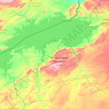
Name: Kariba topographic map, elevation, terrain.
Location: Kariba, Mashonaland West Province, Zimbabwe (-17.42499 28.03112 -16.36787 29.21512)
Average elevation: 668 m
Minimum elevation: 371 m
Maximum elevation: 1,372 m
Other topographic maps
Click on a map to view its topography, its elevation and its terrain.
Ngezi
Zimbabwe > Mashonaland West Province > Kadoma > Turf Village 3
Ngezi, Turf Village 3, Kadoma, Mashonaland West Province, Zimbabwe
Average elevation: 1,213 m
Chidamoyo
Zimbabwe > Mashonaland West Province > Hurungwe
Chidamoyo, Hurungwe, Mashonaland West Province, Zimbabwe
Average elevation: 910 m
Nyabira
Zimbabwe > Mashonaland West Province > Zvimba
Nyabira, Zvimba, Mashonaland West Province, Zimbabwe
Average elevation: 1,429 m
Karoi
Zimbabwe > Mashonaland West Province > Hurungwe
Karoi, Hurungwe, Mashonaland West Province, Zimbabwe
Average elevation: 1,274 m
Chirundu
Zimbabwe > Mashonaland West Province > Hurungwe
Chirundu, Hurungwe, Mashonaland West Province, Zimbabwe
Average elevation: 411 m
Fothergill Island
Zimbabwe > Mashonaland West Province > Kariba
Fothergill Island, Kariba, Mashonaland West Province, Zimbabwe
Average elevation: 487 m
Chinhoyi
Zimbabwe > Mashonaland West Province > Makonde
Chinhoyi, Makonde, Mashonaland West Province, Zimbabwe
Average elevation: 1,167 m