
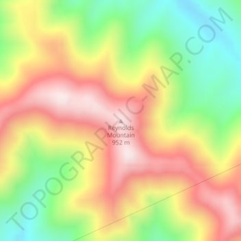
Reynolds Mountain topographic map
Interactive map
Click on the map to display elevation.
About this map
Name: Reynolds Mountain topographic map, elevation, terrain.
Location: Reynolds Mountain, Harlan County, Kentucky, 40863, USA (36.78393 -83.46746 36.78403 -83.46736)
Average elevation: 685 m
Minimum elevation: 413 m
Maximum elevation: 945 m
Other topographic maps
Click on a map to view its topography, its elevation and its terrain.
Daniel Boone National Forest
Daniel Boone National Forest, Forest Road, Lakes, Jackson County, Kentucky, USA
Average elevation: 341 m
Herrington Lake
USA > Kentucky > Little Needmore
Herrington Lake, Taylor Road, Little Needmore, Boyle County, Kentucky, USA
Average elevation: 261 m
Floyds Fork
USA > Kentucky > Louisville
Floyds Fork, Louisville, Jefferson County, Kentucky, 40023, USA
Average elevation: 191 m
Grayson Lake
Grayson Lake, Horton Flats Road, Bruin, Elliott County, Kentucky, USA
Average elevation: 263 m
Powder Mill
USA > Kentucky > Powder Mill
Powder Mill, Hart County, Kentucky, USA
Average elevation: 204 m
Basil Lewis Park
Basil Lewis Park, Latonia, Covington, Kenton County, Kentucky, USA
Average elevation: 163 m
Stringtown
USA > Kentucky > Stringtown
Stringtown, Boone County, Kentucky, 45233, USA
Average elevation: 215 m
Johnsonville
USA > Kentucky > Johnsonville
Johnsonville, Anderson County, Kentucky, USA
Average elevation: 228 m
Henry Mountain
Henry Mountain, Estill County, Kentucky, 40336, USA
Average elevation: 240 m
Fishtrap Lake
Fishtrap Lake, Island Creek Road, Phyllis, Pike County, Kentucky, 41554, USA
Average elevation: 402 m
Abraham Lincoln Birthplace National Historic Site
USA > Kentucky > Boundary Oak
Abraham Lincoln Birthplace National Historic Site, Boundary Oak, Larue County, Kentucky, USA
Average elevation: 238 m
Coxs Creek
USA > Kentucky > Coxs Creek
Coxs Creek, Nelson County, Kentucky, 40013, USA
Average elevation: 197 m
Falling Branch
USA > Kentucky > Falling Branch
Falling Branch, Grayson County, Kentucky, 40119, USA
Average elevation: 171 m
Harrods Creek
USA > Kentucky > Harrods Creek
Harrods Creek, Jefferson County, Kentucky, 40059, USA
Average elevation: 154 m
Cumberland Island
Cumberland Island, Livingston County, Kentucky, USA
Average elevation: 100 m
William Whitley House State Shrine
USA > Kentucky > Sugar Grove
William Whitley House State Shrine, Sugar Grove, Lincoln County, Kentucky, USA
Average elevation: 284 m
General James Taylor Park
General James Taylor Park, Newport, Campbell County, Kentucky, USA
Average elevation: 158 m
Beargrass Creek
USA > Kentucky > Louisville
Beargrass Creek, Louisville, Jefferson County, Kentucky, USA
Average elevation: 143 m
Society Hill
Society Hill, Metcalfe County, Kentucky, 42129, USA
Average elevation: 286 m
Mount Morgan
Mount Morgan, Whitley County, Kentucky, 40769, USA
Average elevation: 374 m
Green River Lake
Green River Lake, Hayes Lane, Atchison, Taylor County, Kentucky, USA
Average elevation: 242 m
White Pine Hollow
White Pine Hollow, Rowan County, Kentucky, USA
Average elevation: 324 m
Raven Run Nature Sanctuary
Raven Run Nature Sanctuary, Lexington, Fayette County, Kentucky, USA
Average elevation: 266 m
Kentucky Horse Park
USA > Kentucky > Spindletop Estates
Kentucky Horse Park, Spindletop Estates, Fayette County, Kentucky, USA
Average elevation: 275 m
Kincaid Lake
Kincaid Lake, Buckeye Hills Road, Concord, Pendleton County, Kentucky, USA
Average elevation: 216 m
Evan Williams Distillerie
Evan Williams Distillerie, Gilkey Run Road, Bardstown, Nelson County, Kentucky, 40004, USA
Average elevation: 181 m
Beckley Creek Park
USA > Kentucky > Louisville
Beckley Creek Park, 1411, Louisville, Jefferson County, Kentucky, 40245, USA
Average elevation: 198 m