
Neu-Ulm topographic map
Interactive map
Click on the map to display elevation.
About this map
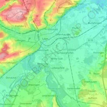
Name: Neu-Ulm topographic map, elevation, terrain.
Location: Neu-Ulm, Landkreis Neu-Ulm, Bavaria, Germany (48.33103 9.96743 48.43350 10.13160)
Average elevation: 498 m
Minimum elevation: 451 m
Maximum elevation: 626 m
Other topographic maps
Click on a map to view its topography, its elevation and its terrain.
Wullenstetten
Germany > Bavaria > Landkreis Neu-Ulm > Senden
Wullenstetten, Senden, Landkreis Neu-Ulm, Bavaria, 89250, Germany
Average elevation: 504 m