
Kantora topographic map
Interactive map
Click on the map to display elevation.
About this map
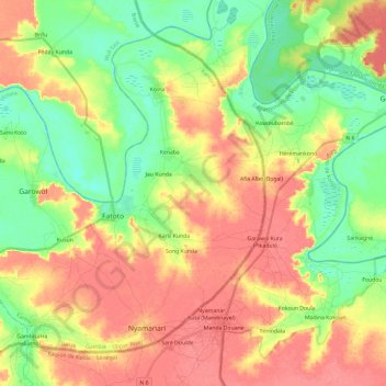
Name: Kantora topographic map, elevation, terrain.
Location: Kantora, Basse, Upper River Division, The Gambia (13.31806 -14.03432 13.50733 -13.79778)
Average elevation: 32 m
Minimum elevation: 2 m
Maximum elevation: 61 m
Other topographic maps
Click on a map to view its topography, its elevation and its terrain.
Tumana
The Gambia > Upper River Division
Tumana, Basse, Upper River Division, The Gambia
Average elevation: 31 m
Perai
The Gambia > Upper River Division > Tumana
Perai, Tumana, Basse, Upper River Division, The Gambia
Average elevation: 18 m