
Alp topographic map
Interactive map
Click on the map to display elevation.
About this map
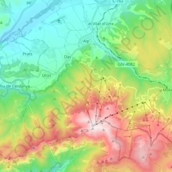
Name: Alp topographic map, elevation, terrain.
Location: Alp, Cerdanya, Girona, Catalonia, 17538, Spain (42.30755 1.86860 42.38278 2.01515)
Average elevation: 1,570 m
Minimum elevation: 1,031 m
Maximum elevation: 2,535 m
Other topographic maps
Click on a map to view its topography, its elevation and its terrain.
Escadarcs
Spain > Catalonia > Cerdanya > Fontanals de Cerdanya > el Vilar d'Urtx
Escadarcs, el Vilar d'Urtx, Fontanals de Cerdanya, Cerdanya, Girona, Catalonia, 17538, Spain
Average elevation: 1,166 m