
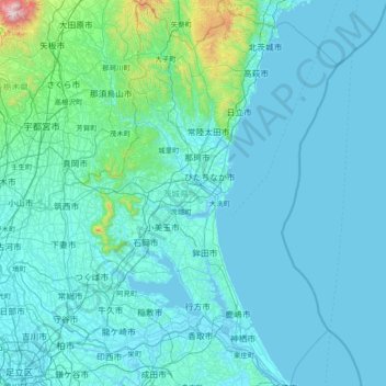
Ibaraki Prefecture topographic map
Interactive map
Click on the map to display elevation.
About this map
Name: Ibaraki Prefecture topographic map, elevation, terrain.
Location: Ibaraki Prefecture, Japan (35.73914 139.68769 36.94530 141.03080)
Average elevation: 82 m
Minimum elevation: -3 m
Maximum elevation: 1,705 m
The northern third of the prefecture is mountainous and in the center is the Tsukuba Mountains (筑波 山地). Its main mountains are: mount Yamizo with an elevation of 1022 m on the border with Fukushima and Tochigi prefectures (tripoint), mount Takasasa with 922 m, mount Tsukuba with two peaks Nyotai-San at 877 m and Nantai-San at 871 m, mount Osho at 804 m, mount Hanazono at 798 m, and mount Kaba at 709 m.
Other topographic maps
Click on a map to view its topography, its elevation and its terrain.
Mount Fuji
Japan > Sunto County > Oyama
Mount Fuji, Oyama, Sunto County, Shizuoka Prefecture, Chubu Region, Japan
Average elevation: 3,261 m
Lake Sanaru
Lake Sanaru, Hamamatsu, Shizuoka Prefecture, Chubu Region, Japan
Average elevation: 16 m
Motoyama
Motoyama, Nagaoka County, Kochi Prefecture, 781-3601, Japan
Average elevation: 679 m
Setouchi
Setouchi, Oshima County, Kagoshima Prefecture, Japan
Average elevation: 26 m
Higashishirakawa
Higashishirakawa, Kamo County, Gifu Prefecture, Chubu Region, 509-1392, Japan
Average elevation: 658 m
Nishikigaoka-chuo Park
Nishikigaoka-chuo Park, Nishikigaoka 2-chome, Aoba Ward, Sendai, Miyagi Prefecture, Japan
Average elevation: 197 m
Katsura Imperial Villa
Katsura Imperial Villa, Road No. 142, Katsura-Kasugacho, Nishikyo Ward, Kyoto, Kyoto Prefecture, 615-8013, Japan
Average elevation: 25 m