
Wendover topographic map
Interactive map
Click on the map to display elevation.
About this map
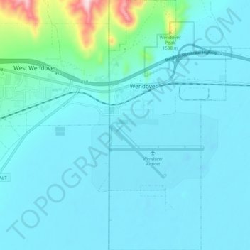
Name: Wendover topographic map, elevation, terrain.
Location: Wendover, Tooele County, Utah, United States (40.68974 -114.04381 40.76227 -113.99902)
Average elevation: 1,325 m
Minimum elevation: 1,279 m
Maximum elevation: 1,770 m
Other topographic maps
Click on a map to view its topography, its elevation and its terrain.
Dolomite
United States > Utah > Tooele County
Dolomite, Tooele County, Utah, United States
Average elevation: 1,324 m
Bonneville Salt Flats State Park
United States > Utah > Tooele County
Bonneville Salt Flats State Park, Tooele County, Utah, United States
Average elevation: 1,284 m