
Gwalior topographic map
Click on the map to display elevation.
Gwalior
Gwalior is located at 26°13′N 78°11′E / 26.22°N 78.18°E / 26.22; 78.18. in northern Madhya Pradesh 300 km (186 miles) from Delhi. It has an average elevation of 197 metres (646 feet). Most part of it comes under the Bundelkhand area.
About this map
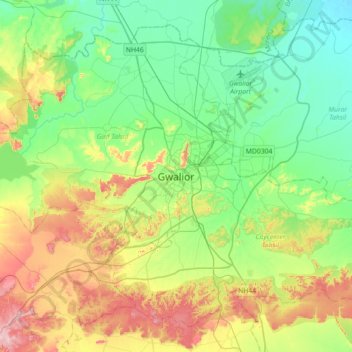
Name: Gwalior topographic map, elevation, terrain.
Location: Gwalior, Gird Tahsil, Gwalior, Madhya Pradesh, 474001, India (26.04372 77.99736 26.36372 78.31736)
Average elevation: 235 m
Minimum elevation: 165 m
Maximum elevation: 382 m