
Seoul topographic map
Interactive map
Click on the map to display elevation.
About this map
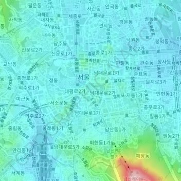
Name: Seoul topographic map, elevation, terrain.
Location: Sogong-dong, Jung-gu, Seoul, South Korea (37.55936 126.96671 37.56979 126.98257)
Average elevation: 56 m
Minimum elevation: 25 m
Maximum elevation: 265 m
Other topographic maps
Click on a map to view its topography, its elevation and its terrain.
Euljiro 7-ga
South Korea > Seoul > Jung-gu > Euljiro 7-ga
Euljiro 7-ga, Jung-gu, Seoul, 04566, South Korea
Average elevation: 55 m