
Vijayawada topographic map
Interactive map
Click on the map to display elevation.
Vijayawada
Vijayawada lies on the banks of Krishna river, covered by hills and canals. and at an altitude of 11 m (36 ft) above sea level. Three canals originating from the north side of the Prakasam Barrage reservoir — Eluru, Bandar, and Ryves — flow through the city.
About this map
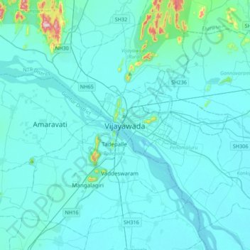
Name: Vijayawada topographic map, elevation, terrain.
Location: Vijayawada, NTR, Andhra Pradesh, 520001, India (16.35153 80.45605 16.67153 80.77605)
Average elevation: 37 m
Minimum elevation: 7 m
Maximum elevation: 448 m
Other topographic maps
Click on a map to view its topography, its elevation and its terrain.
Banakacharla to VBR Link Canal
India > Andhra Pradesh > Jupadu Bungalow > Pothulapadu
Average elevation: 266 m
Andhrapradesh Forest Departement Head Office , Jilledu Makivalasa
India > Andhra Pradesh > Narasannapeta > Tamarapalle
Average elevation: 37 m
East Godavari
East Godavari occupies an area of 12,805 square kilometres (4,944 sq mi), comparatively equivalent to Indonesia's Sumba Island. The district is bounded on north by Visakhapatnam district, Malkangiri district of Orissa on the northwest by Khammam district and Sukma district of Chhattisgarh, on the east and…
Average elevation: 60 m
Anantapur
Penna, Chithravathi, Pedda Hagari, Chinna Hagari, Thadakaleru and Pandameru are the main rivers. The average elevation is about 1300 feet above the mean sea level. The annual normal rainfall of the district is 508.2 mm. Thus it secures least rainfall when compared to other parts of Andhra Pradesh.
Average elevation: 455 m