
Finnmark topographic map
Interactive map
Click on the map to display elevation.
About this map
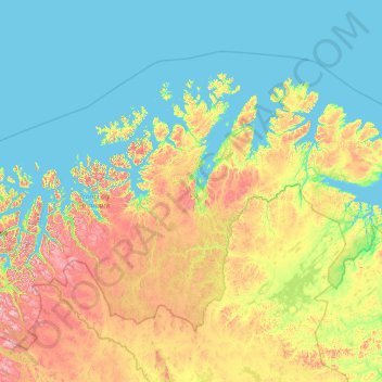
Name: Finnmark topographic map, elevation, terrain.
Location: Finnmark, Norway (68.55459 20.47973 71.38488 31.76149)
Average elevation: 227 m
Minimum elevation: -2 m
Maximum elevation: 1,824 m
The interior parts of the county are part of the great Finnmarksvidda plateau, with an elevation of 300 to 400 m (980 to 1,310 ft), with numerous lakes and river valleys. The plateau is famous for its tens of thousands of reindeer owned by the Sami, and swarms of mosquitos in mid-summer. Finnmarksvidda makes up 36% of the county's area. Stabbursdalen National Park ensures protection for the world's most northern pine forest.