
Troms topographic map
Interactive map
Click on the map to display elevation.
About this map
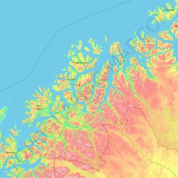
Name: Troms topographic map, elevation, terrain.
Location: Troms, Norway (68.35601 15.59254 70.70362 22.89447)
Average elevation: 293 m
Minimum elevation: -5 m
Maximum elevation: 1,824 m
Skibotn (elevation: 46 m or 151 ft) in Storfjord is the location in Norway which has recorded the most days per year with clear skies (no clouds). Winter temperatures in Målselv and Bardu can get down to −35 °C (−31 °F), while summer days can reach 30 °C (86 °F) in inland valleys and the innermost fjord areas, but 15 to 22 °C (59 to 72 °F) is much more common. Along the outer seaboard, a summer day at 15 °C (59 °F) is considered fairly warm.