
Make a donation
Gear up for your next adventure:
As an Amazon Associate, this site earns from qualifying purchases at no extra cost to you.
Chandigarh topographic map
Click on the map to display elevation.
Make a donation
Gear up for your next adventure:
As an Amazon Associate, this site earns from qualifying purchases at no extra cost to you.
Chandigarh
Chandigarh is located near the foothills of the Sivalik range of the Himalayas in northwest India. It covers an area of approximately 114 km2. It borders the states of Haryana and Punjab. The exact geographic co-ordinates of Chandigarh are 30°44′N 76°47′E / 30.74°N 76.79°E / 30.74; 76.79. It has an average elevation of 321 metres (1053 ft).
Make a donation
Gear up for your next adventure:
As an Amazon Associate, this site earns from qualifying purchases at no extra cost to you.
About this map
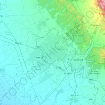
Name: Chandigarh topographic map, elevation, terrain.
Location: Chandigarh, 160018, India (30.57344 76.61971 30.89344 76.93971)
Average elevation: 378 m
Minimum elevation: 276 m
Maximum elevation: 1,651 m
Make a donation
Gear up for your next adventure:
As an Amazon Associate, this site earns from qualifying purchases at no extra cost to you.