
Kathmandu topographic map
Interactive map
Click on the map to display elevation.
About this map
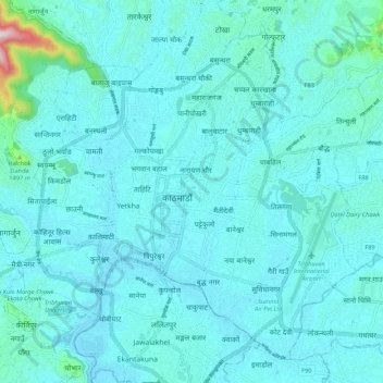
Name: Kathmandu topographic map, elevation, terrain.
Location: Kathmandu, Bagmati Pradesh, Nepal (27.66795 85.26809 27.75132 85.37348)
Average elevation: 1,335 m
Minimum elevation: 1,275 m
Maximum elevation: 2,027 m
Kathmandu, officially Kathmandu Metropolitan City, is the capital and most populous city of Nepal with 845,767 inhabitants living in 105,649 households in 2021 and 2.9 million people in its urban agglomeration. It is located in the Kathmandu Valley, a large valley in the high plateaus in central Nepal, at an altitude of 1,400 metres (4,600 feet).
Other topographic maps
Click on a map to view its topography, its elevation and its terrain.