
Ho Chi Minh City topographic map
Interactive map
Click on the map to display elevation.
Ho Chi Minh City
Ho Chi Minh City is located in the south-eastern region of Vietnam, 1,760 km (1,090 mi) south of Hanoi. The average elevation is 5 m (16 ft) above sea level for the city centre and 16 m (52 ft) for the suburb areas. It borders Tây Ninh Province and Bình Dương Province to the north, Đồng Nai Province and Bà Rịa–Vũng Tàu province to the east, Long An Province to the west, Tien Giang Province and East Sea to the south with a coast 15 km (9 mi) long. The city covers an area of 2,095 km2 (809 sq mi or 0.63% of the surface of Vietnam), extending up to Củ Chi District (12 mi or 19 km from the Cambodian border) and down to Cần Giờ on the Eastern Sea. The distance from the northernmost point (Phú Mỹ Hưng Commune, Củ Chi District) to the southernmost one (Long Hòa Commune, Cần Giờ District) is 102 km (63 mi), and from the easternmost point (Long Bình ward, District Nine) to the westernmost one (Bình Chánh Commune, Bình Chánh District) is 47 km (29 mi). Due to its location on the Mekong Delta, the city is fringed by tidal flats that have been heavily modified for agriculture.
About this map
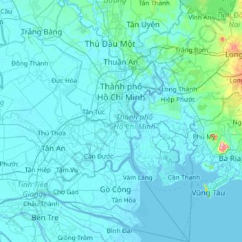
Name: Ho Chi Minh City topographic map, elevation, terrain.
Location: Ho Chi Minh City, Vietnam (10.13995 106.35670 11.16031 107.02767)
Average elevation: 17 m
Minimum elevation: -4 m
Maximum elevation: 498 m
Other topographic maps
Click on a map to view its topography, its elevation and its terrain.
Ho Chi Minh City
Ho Chi Minh City is located in the south-eastern region of Vietnam, 1,760 km (1,090 mi) south of Hanoi. The average elevation is 5 m (16 ft) above sea level for the city center and 16 m (52 ft) for the suburb areas. It borders Tây Ninh Province and Bình Dương Province to the north, Đồng Nai Province and…
Average elevation: 6 m
Ba Den Mountain
Vietnam > Tay Ninh province > Phường Bình Minh
In early December 1974 heavy combat in Tây Ninh began, with People's Army of Vietnam (PAVN) rockets falling on the province capital and on adjacent military installations. The 80-man 3rd Company, 314th Regional Force Battalion guarding the radio relay station on the summit of Nui Ba Den began receiving…
Average elevation: 441 m
Công Viên Trường Đại Học Phú Yên
Vietnam > Đắk Lắk province > Phường Tuy Hòa > Tuy Hòa
Average elevation: 6 m
Quy Nhơn
Vietnam > Gia Lai Province > Phường Quy Nhơn
Quy Nhon has a varied topography, being extremely diversified with mountains and forests, hills, fields, salt marshes, plains, lagoons, lakes, rivers, shorelines, peninsulas and islands. Its coastline is 42 kilometres or 26 miles long with sandy beaches, abundant seafood resources and other natural products of…
Average elevation: 58 m
Yersin Park
Vietnam > Lâm Đồng Province > Phường Xuân Hương - Đà Lạt > Da Lat
Average elevation: 1,482 m
Hạ Long Bay
Vietnam > Quang Ninh Province > Ha Long
Due to a simultaneous combination of ideal factors such as thick, pale, grey, and strong limestone layers, which are formed by fine-grained materials; hot and moist climate and slow tectonic process as a whole; Hạ Long Bay has had a complete karst evolution for 20 million years. There are many types of karst…
Average elevation: 0 m
Huế
The Perfume River (called Sông Hương or Hương Giang in Vietnamese) passes through the center of province. The province also accommodates the Tam Giang–Cau Hai lagoon, the largest lagoon in Southeast Asia, which is 68 kilometres (42 mi) long with a surface area of 220 square kilometres (85 sq mi). The…
Average elevation: 30 m