
Nairobi topographic map
Interactive map
Click on the map to display elevation.
About this map
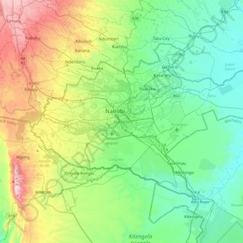
Name: Nairobi topographic map, elevation, terrain.
Location: Nairobi, Nairobi County, Nairobi, Kenya (-1.44488 36.66470 -1.16067 37.10487)
Average elevation: 1,729 m
Minimum elevation: 1,456 m
Maximum elevation: 2,442 m
Other topographic maps
Click on a map to view its topography, its elevation and its terrain.
Nairobi River
Kenya > Nairobi County > Starehe > Nairobi
Nairobi River, City Centre sublocation, Starehe location, Nairobi, CBD division, Starehe, Nairobi County, Nairobi, 46464, Kenya
Average elevation: 1,687 m