Geolocate
👉 Easily get elevation data in JSON, GeoTIFF and KML formats using Elevation API
Thank you for supporting this site ❤️
Make a donation

Gear up for your next adventure:

As an Amazon Associate, this site earns from qualifying purchases at no extra cost to you.

Amman topographic map

Click on the map to display elevation.

Gear up for your next adventure:

As an Amazon Associate, this site earns from qualifying purchases at no extra cost to you.

Amman

Amman is situated on the East Bank Plateau, an upland characterized by three major wadis which run through it. Originally, the city had been built on seven hills. Amman's terrain is typified by its mountains. The most important areas in the city are named after the hills or mountains they lie on. The area's elevation ranges from 1,000 to 1,100 m (3,300 to 3,600 ft). Al-Salt and al-Zarqa are located to the northwest and northeast, respectively, Madaba is located to the west, and al-Karak and Ma'an are to Amman's southwest and southeast, respectively. One of the only remaining springs in Amman now supplies the Zarqa River with water.

Wikipedia (CC-BY-SA 3.0)

👉 Easily get elevation data in JSON, GeoTIFF and KML formats using Elevation API
Thank you for supporting this site ❤️
Make a donation

Gear up for your next adventure:

As an Amazon Associate, this site earns from qualifying purchases at no extra cost to you.

About this map

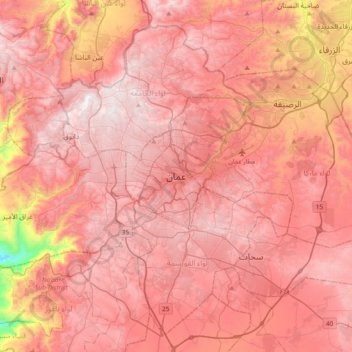
Name: Amman topographic map, elevation, terrain.

Location: Amman, Amman Sub-District, Amman Qasabah District, Amman, 11118, Jordan (31.79157 35.76396 32.11157 36.08396)

Average elevation: 800 m

Minimum elevation: 91 m

Maximum elevation: 1,097 m

Other topographic maps

Click on a map to view its topography, its elevation and its terrain.

Housing Bank Garden

Jordan > Amman > Amman Sub-District > Amman

Average elevation: 898 m

Abdoun

Jordan > Amman > Amman Sub-District > Amman

Average elevation: 896 m