
Angola topographic map
Interactive map
Click on the map to display elevation.
About this map
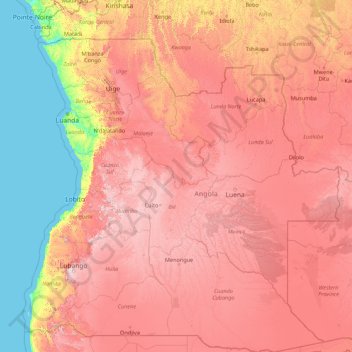
Name: Angola topographic map, elevation, terrain.
Location: Angola (-18.03938 11.46098 -4.34580 24.08764)
Average elevation: 834 m
Minimum elevation: 0 m
Maximum elevation: 2,468 m
Like the rest of tropical Africa, Angola experiences distinct, alternating rainy and dry seasons. In the north, the rainy season may last for as long as seven months—usually from September to April, with perhaps a brief slackening in January or February. In the south, the rainy season begins later, in November, and lasts until about February. The dry season (cacimbo) is often characterized by a heavy morning mist. In general, precipitation is higher in the north, but at any latitude it is greater in the interior than along the coast and increases with altitude. Temperatures fall with distance from the equator and with altitude and tend to rise closer to the Atlantic Ocean. Thus, at Soyo, at the mouth of the Congo River, the average annual temperature is about 26 °C, but it is under 16 °C at Huambo on the temperate central plateau. The coolest months are July and August (in the middle of the dry season), when frost may sometimes form at higher altitudes.
Other topographic maps
Click on a map to view its topography, its elevation and its terrain.
The World
United Arab Emirates > Dubai > Dubai
The World, Dubai, United Arab Emirates
Average elevation: 0 m
Europe
Europe
Average elevation: 223 m
Ukraine
Ukraine
Average elevation: 183 m
United Kingdom
United Kingdom
Average elevation: 42 m
London
United Kingdom > England > London
London, Greater London, England, SW1A 2DX, United Kingdom
Average elevation: 42 m
Indonesia
Indonesia
Average elevation: 81 m
Turkey
Turkey
Average elevation: 487 m
Sweden
Sweden
Average elevation: 163 m
India
India
Average elevation: 1,017 m
Chennai
India > Tamil Nadu > Chennai
Chennai, Chennai District, Tamil Nadu, India
Average elevation: 8 m
Italy
Italy
Average elevation: 293 m
United States
United States
Average elevation: 309 m
North America
North America
Average elevation: 294 m
Poland
Poland
Average elevation: 194 m
Germany
Germany
Average elevation: 237 m
Cotabato City
Philippines > Maguindanao > Cotabato City
Cotabato City, Maguindanao, Soccsksargen, 9600, Philippines
Average elevation: 97 m
Spain
Spain
Average elevation: 331 m
Bengaluru
India > Karnataka > Bangalore North
Bengaluru, Bangalore North, Bengaluru Urban District, Karnataka, India
Average elevation: 881 m
Lithuania
Lithuania
Average elevation: 102 m
Netherlands
Netherlands
Average elevation: 251 m
London
London, Greater London, England, United Kingdom
Average elevation: 66 m
Mexico
Mexico
Average elevation: 412 m
Ocheretyne
Ocheretyne, Ocheretyne settlement hromada, Pokrovskii Raion, Donetsk Oblast, 86020, Ukraine
Average elevation: 227 m
Kenya
Kenya
Average elevation: 717 m
Malta
Malta
Average elevation: 4 m
Sheffield
Sheffield, South Yorkshire, England, United Kingdom
Average elevation: 168 m
Cambridgeshire
Cambridgeshire, Cambridgeshire and Peterborough, England, United Kingdom
Average elevation: 32 m
Albuquerque
United States > New Mexico > Bernalillo County
Albuquerque, Bernalillo County, New Mexico, United States
Average elevation: 1,688 m
Nairobi
Kenya > Nairobi County > Starehe
Nairobi, Nairobi County, Nairobi, Kenya
Average elevation: 1,729 m
Greece
Greece
Average elevation: 170 m
Bristol
United Kingdom > England > City of Bristol
Bristol, City of Bristol, West of England, England, United Kingdom
Average elevation: 55 m
Africa
Africa
Average elevation: 462 m