
Make a donation
Gear up for your next adventure:
As an Amazon Associate, this site earns from qualifying purchases at no extra cost to you.
Minsk topographic map
Click on the map to display elevation.
Make a donation
Gear up for your next adventure:
As an Amazon Associate, this site earns from qualifying purchases at no extra cost to you.
Minsk
Minsk is located on the southeastern slope of the Minsk Hills, a region of rolling hills running from the southwest (upper reaches of the river Nioman) to the northeast– that is, to Lukomskaye Lake in northwestern Belarus. The average altitude above sea level is 220 metres (720 ft). The physical geography of Minsk was shaped over the two most recent ice ages. The Svislach River, which flows across the city from the northwest to the southeast, is in the urstromtal, an ancient river valley formed by water flowing from melting ice sheets at the end of the last Ice Age. There are six smaller rivers within the city limits, all part of the Black Sea basin.
Make a donation
Gear up for your next adventure:
As an Amazon Associate, this site earns from qualifying purchases at no extra cost to you.
About this map
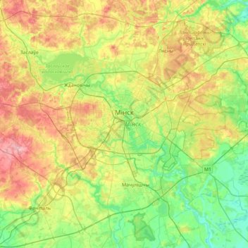
Name: Minsk topographic map, elevation, terrain.
Location: Minsk, Belarus (53.79385 27.37402 53.97179 28.07995)
Average elevation: 222 m
Minimum elevation: 167 m
Maximum elevation: 325 m
Make a donation
Gear up for your next adventure:
As an Amazon Associate, this site earns from qualifying purchases at no extra cost to you.
Other topographic maps
Click on a map to view its topography, its elevation and its terrain.
Слімяны
Belarus > Hrodna Region > Ashmyany District > Крайванцаўскі сельскі Савет
Average elevation: 232 m
Dnieper
Belarus > Homyel Region > Brahin District > Новаялчанскі сельскі Савет
The source of the Dnieper is the sedge bogs (Akseninsky Mokh) of the Valdai Hills in central Russia, at an elevation of 220 m (720 ft). For 115 km (71 mi) of its length, it serves as the border between Belarus and Ukraine. Its estuary, or liman, used to be defended by the strong fortress of Ochakiv.
Average elevation: 106 m
Гара Красная
Belarus > Minsk Region > Uzda District > Слабадскі сельскі Савет
Average elevation: 174 m
Dnieper
Belarus > Homyel Region > Brahin District > Новаялчанскі сельскі Савет
The source of the Dnieper is the sedge bogs (Akseninsky Mokh) of the Valdai Hills in central Russia, at an elevation of 220 m (720 ft). For 115 km (71 mi) of its length, it serves as the border between Belarus and Ukraine. Its estuary, or liman, used to be defended by the strong fortress of Ochakiv.
Average elevation: 106 m
Make a donation
Gear up for your next adventure:
As an Amazon Associate, this site earns from qualifying purchases at no extra cost to you.
Highest point of the Kapyl hill chain
Belarus > Minsk Region > Kapyl District > Пацейкаўскі сельскі Савет
Average elevation: 227 m
Dnieper
Belarus > Homyel Region > Brahin District > Новаялчанскі сельскі Савет
The source of the Dnieper is the sedge bogs (Akseninsky Mokh) of the Valdai Hills in central Russia, at an elevation of 220 m (720 ft). For 115 km (71 mi) of its length, it serves as the border between Belarus and Ukraine. Its estuary, or liman, used to be defended by the strong fortress of Ochakiv.
Average elevation: 106 m
Make a donation
Gear up for your next adventure:
As an Amazon Associate, this site earns from qualifying purchases at no extra cost to you.
озеро Ёди
Belarus > Hrodna Region > Astravyets District > Михалишковский сельский Совет
Average elevation: 140 m