
Lake Geneva topographic map
Interactive map
Click on the map to display elevation.
About this map
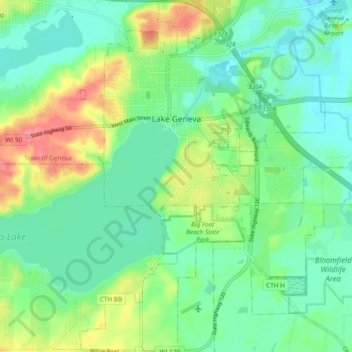
Name: Lake Geneva topographic map, elevation, terrain.
Location: Lake Geneva, Walworth County, Wisconsin, United States (42.54554 -88.45939 42.61510 -88.39359)
Average elevation: 275 m
Minimum elevation: 250 m
Maximum elevation: 327 m
Other topographic maps
Click on a map to view its topography, its elevation and its terrain.
Geneva Lake
United States > Wisconsin > Walworth County > Williams Bay
Geneva Lake, Williams Bay, Town of Linn, Walworth County, Wisconsin, 53125, United States
Average elevation: 288 m
Sharon
United States > Wisconsin > Walworth County
Sharon, Walworth County, Wisconsin, 53585, United States
Average elevation: 303 m