
Herat topographic map
Interactive map
Click on the map to display elevation.
About this map
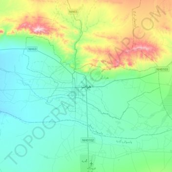
Name: Herat topographic map, elevation, terrain.
Location: Herat, Herat Province, 3001, Afghanistan (34.19083 62.05640 34.51083 62.37640)
Average elevation: 1,042 m
Minimum elevation: 882 m
Maximum elevation: 1,623 m
Other topographic maps
Click on a map to view its topography, its elevation and its terrain.
Ghurian
Afghanistan > Herat Province > Ghurian
Ghurian, Herat Province, Afghanistan
Average elevation: 929 m
Gaza
Afghanistan > Herat Province > Ghurian > Gaza
Gaza, Ghurian, Herat Province, Afghanistan
Average elevation: 786 m