
Corsica topographic map
Interactive map
Click on the map to display elevation.
Corsica
Under the Köppen climate classification scheme, coastal regions are characterized by a hot-summer Mediterranean climate (Csa). Further inland, a warm-summer Mediterranean climate (Csb) is more common. At the highest elevation locations, small areas with a subarctic climate (Dsc, Dfc) and the rare cold-summer Mediterranean climate (Csc) can be found.
About this map
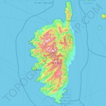
Name: Corsica topographic map, elevation, terrain.
Location: Corsica, Metropolitan France, France (41.33319 8.53472 43.02771 9.56001)
Average elevation: 139 m
Minimum elevation: -5 m
Maximum elevation: 2,546 m
Other topographic maps
Click on a map to view its topography, its elevation and its terrain.
Mont Blanc / Monte Bianco
France > Auvergne-Rhône-Alpes > Upper Savoy > Saint-Gervais-les-Bains
The climate is cold and temperate (Köppen climate classification Cfb), and is greatly influenced by altitude. Being the highest part of the Alps, Mont Blanc and surrounding mountains can create their own weather patterns. Temperatures drop as the mountains gain in height, and the summit of Mont Blanc is a…
Average elevation: 4,092 m
Source du Mirail
France > Provence-Alpes-Côte d'Azur > Vaucluse > Peypin-d'Aigues
Average elevation: 493 m
Le Cailleret
France > Bourgogne – Franche-Comté > Côte-d'Or > Puligny-Montrachet
Average elevation: 276 m
Mont Joly
France > Auvergne-Rhône-Alpes > Upper Savoy > Saint-Gervais-les-Bains
Average elevation: 1,978 m
Val d'Esquieres
France > Provence-Alpes-Côte d'Azur > Var > Roquebrune-sur-Argens
Average elevation: 82 m
Station de ski de Céüze
France > Provence-Alpes-Côte d'Azur > Hautes-Alpes > Manteyer
Average elevation: 1,580 m
Rigaudon
France > Centre-Val de Loire > Loir-et-Cher > Montrichard Val de Cher
Average elevation: 97 m
Uriage Les Bains
France > Auvergne-Rhône-Alpes > Isère > Saint-Martin-d'Uriage
Average elevation: 618 m
Aiguille de Toula
France > Auvergne-Rhône-Alpes > Upper Savoy > Chamonix-Mont-Blanc
Average elevation: 3,192 m
Valiant
France > Auvergne-Rhône-Alpes > Loire > Saint-Bonnet-des-Quarts > Le Royer
Average elevation: 623 m
Le Pied du Col
France > Provence-Alpes-Côte d'Azur > Hautes-Alpes > Villar-d'Arêne
Average elevation: 2,101 m
Ailefroide
France > Provence-Alpes-Côte d'Azur > Hautes-Alpes > Vallouise-Pelvoux
Average elevation: 2,039 m
Molanès
France > Provence-Alpes-Côte d'Azur > Alpes-de-Haute-Provence > Uvernet-Fours
Average elevation: 1,566 m