
Mingachevir Reservoir topographic map
Interactive map
Click on the map to display elevation.
About this map
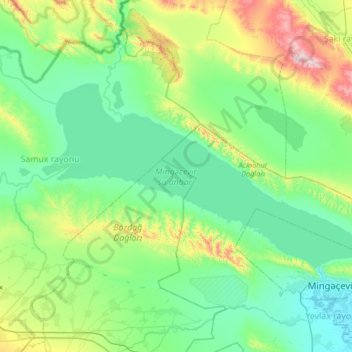
Name: Mingachevir Reservoir topographic map, elevation, terrain.
Average elevation: 175 m
Minimum elevation: 16 m
Maximum elevation: 805 m
Vagif Dargahli, spokesperson of Azerbaijan's Ministry of Defense stated in July 2020 that the "land topography of the Mingachevir water reservoir, protective land works in the area and advanced air defense systems in service with the country’s missile defense troops make a strike on this strategically important facility impossible."
Other topographic maps
Click on a map to view its topography, its elevation and its terrain.
Goygol District
Goygol District, Ganja-Dashkasan, 2500, Azerbaijan
Average elevation: 1,197 m
Ganja City
Ganja City, Ganja-Dashkasan, Azerbaijan
Average elevation: 440 m