
Imatra topographic map
Interactive map
Click on the map to display elevation.
About this map
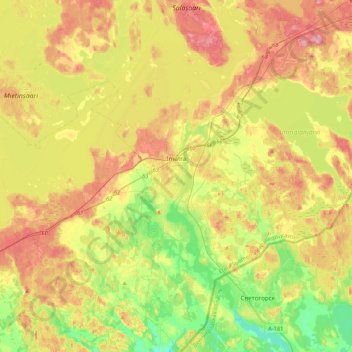
Name: Imatra topographic map, elevation, terrain.
Average elevation: 75 m
Minimum elevation: 21 m
Maximum elevation: 135 m
Other topographic maps
Click on a map to view its topography, its elevation and its terrain.
Lantta
Finland > South Karelia > Savitaipale
Lantta, Savitaipale, Lappeenranta sub-region, South Karelia, Southern Finland, Mainland Finland, Finland
Average elevation: 99 m
Lappeenranta
Lappeenranta, Lappeenranta sub-region, South Karelia, Southern Finland, Mainland Finland, Finland
Average elevation: 63 m