
Borneo topographic map
Interactive map
Click on the map to display elevation.
About this map
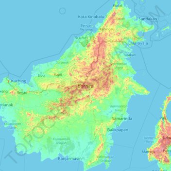
Name: Borneo topographic map, elevation, terrain.
Location: Borneo, Kalimantan, Indonesia (-4.17791 108.84066 7.03748 119.26689)
Average elevation: 141 m
Minimum elevation: -4 m
Maximum elevation: 3,808 m
Before sea levels rose at the end of the last ice age, Borneo was part of the mainland of Asia, forming, with Java and Sumatra, the upland regions of a peninsula that extended east from present day Indochina. The South China Sea and Gulf of Thailand now submerge the former low-lying areas of the peninsula. Deeper waters separating Borneo from neighbouring Sulawesi prevented a land connection to that island, creating the divide known as Wallace's Line between Asian and Australia-New Guinea biological regions. The island today is surrounded by the South China Sea to the north and northwest, the Sulu Sea to the northeast, the Celebes Sea and the Makassar Strait to the east, and the Java Sea and Karimata Strait to the south. To the west of Borneo are the Malay Peninsula and Sumatra. To the south and east are islands of Indonesia: Java and Sulawesi, respectively. To the northeast are the Philippine Islands. With an area of 743,330 square kilometres (287,000 sq mi), it is the third-largest island in the world, and is the largest island of Asia (the largest continent). Its highest point is Mount Kinabalu in Sabah, Malaysia, with an elevation of 4,095 m (13,435 ft).
Other topographic maps
Click on a map to view its topography, its elevation and its terrain.
Kondangjaya
Indonesia > West Java > Karawang
Kondangjaya, Karawang Timur, Karawang, West Java, Java, 41371, Indonesia
Average elevation: 19 m
Getasan
Indonesia > Central Java > Semarang
Getasan, Semarang, Central Java, Java, 50774, Indonesia
Average elevation: 1,073 m
Perum Griya Yasa Lestari
Perum Griya Yasa Lestari, Bojonggede, Bogor, West Java, Java, 16922, Indonesia
Average elevation: 135 m
Lombok
Indonesia > West Nusa Tenggara
Lombok, West Nusa Tenggara, Lesser Sunda Islands, Indonesia
Average elevation: 192 m
Kampung Pasir
Indonesia > Aceh > Aceh Barat
Kampung Pasir, Johan Pahlawan, Aceh Barat, Aceh, Sumatra, Indonesia
Average elevation: 3 m
Special Capital Region of Jakarta
Special Capital Region of Jakarta, Java, Indonesia
Average elevation: 5 m
Plaosan
Indonesia > Central Java > Pati
Plaosan, Pati, Central Java, Java, Indonesia
Average elevation: 236 m
Mount Sindoro
Indonesia > Central Java > Wonosobo > Wonosobo
Mount Sindoro, Wonosobo, Central Java, Java, Indonesia
Average elevation: 2,572 m
Mount Bromo
Indonesia > East Java > Pasuruan
Mount Bromo, Pasuruan, East Java, Java, 67254, Indonesia
Average elevation: 2,239 m
Api-api
Indonesia > East Kalimantan > Bontang
Api-api, Bontang, East Kalimantan, Kalimantan, 75311, Indonesia
Average elevation: 6 m
Kalideres
Indonesia > Special Region of Jakarta
Kalideres, West Jakarta, Special Region of Jakarta, Java, Indonesia
Average elevation: 6 m
Satimpo
Indonesia > East Kalimantan > Bontang
Satimpo, Bontang, East Kalimantan, Kalimantan, 75324, Indonesia
Average elevation: 12 m
Tawangsari
Indonesia > Central Java > Sukoharjo
Tawangsari, Sukoharjo, Central Java, Java, 57561, Indonesia
Average elevation: 115 m
Sangir Island
Indonesia > North Sulawesi > Kepulauan Sangihe
Sangir Island, Kepulauan Sangihe, North Sulawesi, Sulawesi, 95811, Indonesia
Average elevation: 77 m
Desa Galam, Kecamatan Bajuin, Tanah Laut
Indonesia > South Kalimantan > Tanah Laut
Desa Galam, Kecamatan Bajuin, Tanah Laut, Tanah Laut, South Kalimantan, Kalimantan, Indonesia
Average elevation: 113 m
Bajuin
Indonesia > South Kalimantan > Tanah Laut
Bajuin, Tanah Laut, South Kalimantan, Kalimantan, Indonesia
Average elevation: 37 m
Gunung Prau
Indonesia > East Java > Ponorogo
Gunung Prau, Ponorogo, East Java, Java, Indonesia
Average elevation: 1,464 m
Batu Ampar
Indonesia > South Kalimantan > Tanah Laut
Batu Ampar, Tanah Laut, South Kalimantan, Kalimantan, Indonesia
Average elevation: 39 m
Gunung Sarik
Indonesia > West Sumatra > Padang
Gunung Sarik, Padang, West Sumatra, Sumatra, 25158, Indonesia
Average elevation: 31 m
Bakti Jaya
Indonesia > West Java > Bogor > Depok
Bakti Jaya, Depok, Bogor, West Java, Java, 16417, Indonesia
Average elevation: 82 m
Pingit
Indonesia > Central Java > Banjarnegara
Pingit, Banjarnegara, Central Java, Java, Indonesia
Average elevation: 125 m
Candisari
Indonesia > Central Java > Semarang
Candisari, Semarang, Central Java, Java, 50251, Indonesia
Average elevation: 126 m
Pakem
Indonesia > Special Region of Yogyakarta > Sleman Regency
Pakem, Sleman Regency, Special Region of Yogyakarta, Java, 55582, Indonesia
Average elevation: 670 m
Bogani Nani Wartabone National Park
Indonesia > North Sulawesi > Bolaang Mongondow Utara
Bogani Nani Wartabone National Park, Bolaang Mongondow Utara, North Sulawesi, Sulawesi, Indonesia
Average elevation: 186 m
Temon
Indonesia > Special Region of Yogyakarta > Kulon Progo > Temonkulon
Temon, Temonkulon, Temon, Kulon Progo, Special Region of Yogyakarta, Java, 55654, Indonesia
Average elevation: 30 m
Paniki Dua
Indonesia > North Sulawesi > Minahasa Utara
Paniki Dua, Minahasa Utara, North Sulawesi, Sulawesi, 95370, Indonesia
Average elevation: 106 m
Ungaran
Indonesia > Central Java > Semarang
Ungaran, Semarang, Central Java, Java, 50511, Indonesia
Average elevation: 357 m
Hutabalang
Indonesia > North Sumatra > Central Tapanuli
Hutabalang, Central Tapanuli, North Sumatra, Sumatra, Indonesia
Average elevation: 20 m
Lubuk Ampolu
Indonesia > North Sumatra > Central Tapanuli
Lubuk Ampolu, Central Tapanuli, North Sumatra, Sumatra, Indonesia
Average elevation: 25 m
Hutan Kota Patriot Bina Bangsa Kota Bekasi
Indonesia > West Java > Bekasi > Kayuringinjaya
Hutan Kota Patriot Bina Bangsa Kota Bekasi, Kranji, Proyek, Kayuringinjaya, Bekasi, West Java, Java, Indonesia
Average elevation: 19 m
Nagari Surian
Indonesia > West Sumatra > Solok
Nagari Surian, Solok, West Sumatra, Sumatra, Indonesia
Average elevation: 1,061 m
Lumut
Indonesia > West Kalimantan > Sanggau
Lumut, Toba, Sanggau, West Kalimantan, Kalimantan, Indonesia
Average elevation: 82 m
Banguntapan
Indonesia > Special Region of Yogyakarta > Bantul Regency
Banguntapan, Bantul Regency, Special Region of Yogyakarta, Java, Indonesia
Average elevation: 91 m
Jatimulyo
Indonesia > Lampung > Lampung Selatan
Jatimulyo, Lampung Selatan, Lampung, Sumatra, 35365, Indonesia
Average elevation: 81 m