
Inagua topographic map
Interactive map
Click on the map to display elevation.
About this map
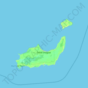
Name: Inagua topographic map, elevation, terrain.
Location: Inagua, The Bahamas (20.70598 -73.91666 21.76100 -72.69290)
Average elevation: 1 m
Minimum elevation: 0 m
Maximum elevation: 30 m
Other topographic maps
Click on a map to view its topography, its elevation and its terrain.
Stanleyville
Stanleyville, New Providence, The Bahamas
Average elevation: 7 m
Harbour Island
Harbour Island, Dunmore Town, Harbour Island, The Bahamas
Average elevation: 1 m
Rose Island
Rose Island, Nassau, New Providence, The Bahamas
Average elevation: 0 m
Williams Island
Williams Island, North Andros, The Bahamas
Average elevation: 0 m
Highbury Park
Highbury Park, New Providence, The Bahamas
Average elevation: 7 m
Grand Bahama
The Bahamas > East Grand Bahama
Grand Bahama, East Grand Bahama, The Bahamas
Average elevation: 1 m
Bimini
The Bahamas > Bimini > Bailey Town
Bimini, Bailey Town, Bimini, The Bahamas
Average elevation: 1 m
Russell Island
Russell Island, Spanish Wells, The Bahamas
Average elevation: 1 m
Charlotteville
Charlotteville, New Providence, The Bahamas
Average elevation: 5 m
Little Whale Cay
The Bahamas > West Grand Bahama
Little Whale Cay, West Grand Bahama, The Bahamas
Average elevation: 0 m