
Gèdre topographic map
Interactive map
Click on the map to display elevation.
About this map
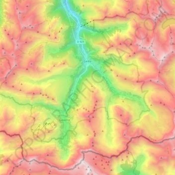
Name: Gèdre topographic map, elevation, terrain.
Average elevation: 2,136 m
Minimum elevation: 801 m
Maximum elevation: 3,294 m
Other topographic maps
Click on a map to view its topography, its elevation and its terrain.
Cirque de Gavarnie
France > Occitania > Hautes Pyrenees > Gavarnie-Gèdre > Gavarnie
Cirque de Gavarnie, Gavarnie, Gavarnie-Gèdre, Argelès-Gazost, Hautes Pyrenees, Occitania, Metropolitan France, 65120, France
Average elevation: 2,364 m
Gavarnie
France > Occitania > Hautes Pyrenees > Gavarnie-Gèdre
Gavarnie, Gavarnie-Gèdre, Argelès-Gazost, Hautes Pyrenees, Occitania, Metropolitan France, 65120, France
Average elevation: 2,119 m