
Portmore topographic map
Interactive map
Click on the map to display elevation.
About this map
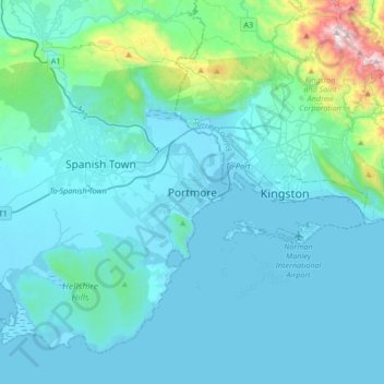
Name: Portmore topographic map, elevation, terrain.
Location: Portmore, Saint Catherine, Middlesex County, Jamaica (17.81179 -77.03380 18.13179 -76.71380)
Average elevation: 148 m
Minimum elevation: -2 m
Maximum elevation: 1,463 m
Other topographic maps
Click on a map to view its topography, its elevation and its terrain.
Bog Walk
Bog Walk, Saint Catherine, Middlesex County, Jamaica
Average elevation: 150 m
Hellshire
Hellshire, Saint Catherine, Middlesex County, Jamaica
Average elevation: 16 m
Time And Patience
Time And Patience, Saint Catherine, Middlesex County, Jamaica
Average elevation: 144 m
Montpelier
Jamaica > Saint Catherine > Spanish Town
Montpelier, Spanish Town, Saint Catherine, Middlesex County, Jamaica
Average elevation: 543 m
Spanish Town
Spanish Town, Saint Catherine, Middlesex County, Jamaica
Average elevation: 136 m