
Apastepeque topographic map
Interactive map
Click on the map to display elevation.
About this map
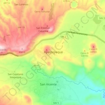
Name: Apastepeque topographic map, elevation, terrain.
Location: Apastepeque, Departamento de San Vicente, El Salvador (13.50792 -88.93962 13.82792 -88.61962)
Average elevation: 474 m
Minimum elevation: 8 m
Maximum elevation: 2,133 m
Apastepeque is a municipality of the San Vicente Department. It is located towards the southeast of the centre of the country to the east of San Salvador and lies at an altitude of 590 m. Bordering to the north is the municipality of San Esteban Catarina, to the north east the municipality of Santa Clara, to the east with San Ildefonso, to the south with Ciudad de San Vicente (the department capital) and to the west with the municipality of San Cayetano Istepeque. It is 6 km from Ciudad de San Vicente and 58 km from San Salvador.
Other topographic maps
Click on a map to view its topography, its elevation and its terrain.
San Vicente
El Salvador > Departamento de San Vicente
San Vicente, Departamento de San Vicente, El Salvador
Average elevation: 450 m