
Aitutaki topographic map
Interactive map
Click on the map to display elevation.
About this map
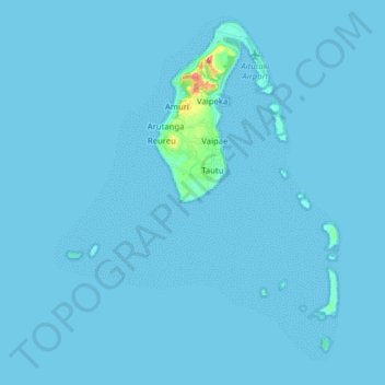
Name: Aitutaki topographic map, elevation, terrain.
Location: Aitutaki, Cook Islands (-18.96409 -159.85365 -18.81564 -159.71255)
Average elevation: 2 m
Minimum elevation: 0 m
Maximum elevation: 109 m
Other topographic maps
Click on a map to view its topography, its elevation and its terrain.
Arutanga
Cook Islands > Aitutaki > Aitutaki > Arutanga
Arutanga, Aitutaki, Cook Islands
Average elevation: 17 m