
Seixal topographic map
Interactive map
Click on the map to display elevation.
About this map
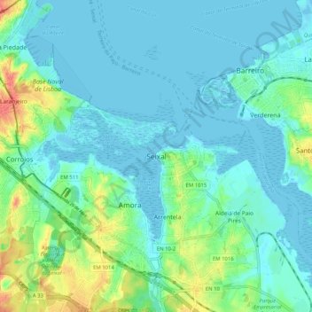
Name: Seixal topographic map, elevation, terrain.
Average elevation: 43 m
Minimum elevation: -3 m
Maximum elevation: 462 m
Although the municipal population continued to grow with development, after the 1970s there was a boom in the population, due to improvements in accessibility and mobility, principally due to public transport, its location to Lisbon and installation of economic activities within the territory. This growth transformed, in a short time, from a territory predominantly rural into an urban municipality, consisting of agglomerations of large dimensions focusing on various establishments and social centres. This growth resulted in the 1993 elevation of Seixal and Amora into cities, and the establishment of Corroios into the status of town.