
War Hill topographic map
Interactive map
Click on the map to display elevation.
About this map
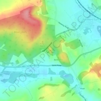
Name: War Hill topographic map, elevation, terrain.
Average elevation: 145 m
Minimum elevation: 110 m
Maximum elevation: 215 m
Other topographic maps
Click on a map to view its topography, its elevation and its terrain.
Silverdale
United Kingdom > England > Newcastle-under-Lyme > Silverdale
Silverdale, Newcastle-under-Lyme, Staffordshire, West Midlands, England, ST5 6QD, United Kingdom
Average elevation: 166 m
Rosemary Hill Wood
United Kingdom > England > Newcastle-under-Lyme > Silverdale
Rosemary Hill Wood, Silverdale, Newcastle-under-Lyme, Staffordshire, West Midlands, England, United Kingdom
Average elevation: 156 m
Miles Green
United Kingdom > England > Newcastle-under-Lyme > Audley > Boon Hill
Miles Green, Boon Hill, Audley Rural, Audley, Newcastle-under-Lyme, Staffordshire, West Midlands, England, ST7 8LH, United Kingdom
Average elevation: 154 m
Betley
United Kingdom > England > Newcastle-under-Lyme
Betley, Newcastle-under-Lyme, Staffordshire, West Midlands, England, United Kingdom
Average elevation: 94 m
Northwood
United Kingdom > England > Newcastle-under-Lyme > Northwood
Northwood, Newcastle-under-Lyme, Staffordshire, England, ST5 4BU, United Kingdom
Average elevation: 130 m
Miry Wood
United Kingdom > England > Newcastle-under-Lyme
Miry Wood, The Drive, Audley Rural, Newcastle-under-Lyme, Staffordshire, West Midlands, England, ST5 6BW, United Kingdom
Average elevation: 172 m
Maer
United Kingdom > England > Newcastle-under-Lyme
Maer, Newcastle-under-Lyme, Staffordshire, West Midlands, England, United Kingdom
Average elevation: 142 m
Whitmore
United Kingdom > England > Newcastle-under-Lyme
Whitmore, Newcastle-under-Lyme, Staffordshire, West Midlands, England, United Kingdom
Average elevation: 147 m