
Mbeya topographic map
Interactive map
Click on the map to display elevation.
About this map
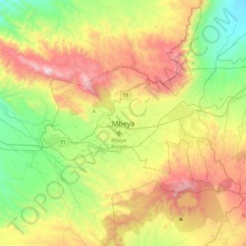
Name: Mbeya topographic map, elevation, terrain.
Average elevation: 1,817 m
Minimum elevation: 1,155 m
Maximum elevation: 2,818 m
Mbeya is situated at an altitude of 1,700 metres (5,500 ft), and sprawls through a narrow highland valley surrounded by a bowl of high mountains. The main language is colloquial Swahili, and the English language is extensively taught in schools.
Other topographic maps
Click on a map to view its topography, its elevation and its terrain.
Uyole
Uyole, Mbeya Municipal, Mbeya Region, Southern Highlands Zone, Tanzania
Average elevation: 1,806 m
Kajunjumele
Kajunjumele, Kyela, Mbeya Region, Southern Highlands Zone, Tanzania
Average elevation: 479 m
Iwambi
Iwambi, Mbeya Municipal, Mbeya Region, Southern Highlands Zone, Tanzania
Average elevation: 1,559 m
Kyela
Kyela, Mbeya Region, Southern Highlands Zone, Tanzania
Average elevation: 490 m
Idunda
Tanzania > Mbeya Region > Idunda
Idunda, Mbeya Municipal, Mbeya Region, Southern Highlands Zone, Tanzania
Average elevation: 1,974 m
Rungwe
Rungwe, Mbeya Region, Southern Highlands Zone, Tanzania
Average elevation: 2,636 m