
Maroochydore topographic map
Interactive map
Click on the map to display elevation.
About this map
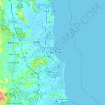
Name: Maroochydore topographic map, elevation, terrain.
Location: Maroochydore, Queensland, 4558, Australia (-26.81565 152.93467 -26.49565 153.25467)
Average elevation: 20 m
Minimum elevation: -2 m
Maximum elevation: 456 m
Other topographic maps
Click on a map to view its topography, its elevation and its terrain.
Landsborough
Australia > Queensland > Maroochydore > Landsborough
Landsborough, Maroochydore, Queensland, 4553, Australia
Average elevation: 69 m
Mooloolabah Esplanade Park
Australia > Queensland > Maroochydore
Mooloolabah Esplanade Park, Mooloolaba, Maroochydore, Queensland, 4557, Australia
Average elevation: 4 m