
Constanța topographic map
Interactive map
Click on the map to display elevation.
About this map
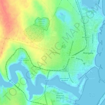
Name: Constanța topographic map, elevation, terrain.
Location: Mangalia, Constanța, Romania (43.80178 28.53307 43.82867 28.59059)
Average elevation: 17 m
Minimum elevation: -4 m
Maximum elevation: 53 m
Other topographic maps
Click on a map to view its topography, its elevation and its terrain.
Bucharest
The city has an area of 226 km2 (87 sq mi). The altitude varies from 55.8 m (183.1 ft) at the Dâmbovița bridge in Cățelu, southeastern Bucharest and 91.5 m (300.2 ft) at the Militari church. The city has a roughly round shape, with the centre situated in the cross-way of the main north–south/east-west…
Average elevation: 82 m
Cluj-Napoca
A wide variety of flora grow in the Cluj-Napoca Botanical Garden; some animals have also found refuge there. The city has a number of other parks, of which the largest is the Central Park. This park was founded during the 19th century and includes an artificial lake with an island, as well as the largest…
Average elevation: 490 m
Carpathian Mountains
The northwestern Carpathians begin in Slovakia and southern Poland. They surround Transcarpathia and Transylvania in a large semicircle, sweeping towards the southeast, and end on the Danube near Orșova in Romania. The total length of the Carpathians is over 1,500 km (930 mi). The mountain chain's width…
Average elevation: 980 m
Băile Herculane
Băile Herculane (Latin: Aqua Herculis; German: Herkulesbad; Hungarian: Herkulesfürdő; Czech: Herkulovy Lázně, Turkish: Lazarethane) is a spa town in Romanian Banat, in Caraș-Severin County, situated in the valley of the Cerna River, between the Mehedinți Mountains to the east and the Cerna Mountains to…
Average elevation: 571 m
Maramureș
Maramureș County is situated in the northern part of Romania, in the historical region of Transylvania, and has a border with Ukraine. This county has a total area of 6,304 square kilometres (2,434 sq mi), of which 43% is covered by the Rodna Mountains, with its tallest peak, Pietrosul [ro], at 2,303 metres…
Average elevation: 700 m