
Pelican Island topographic map
Interactive map
Click on the map to display elevation.
About this map
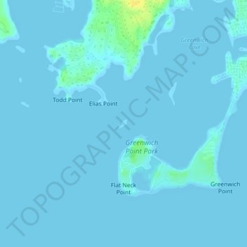
Name: Pelican Island topographic map, elevation, terrain.
Location: Pelican Island, Greenwich, Fairfield, Connecticut, USA (41.00827 -73.58558 41.00928 -73.58432)
Average elevation: 1 m
Minimum elevation: -1 m
Maximum elevation: 21 m
Other topographic maps
Click on a map to view its topography, its elevation and its terrain.
Byram Park
USA > Connecticut > Greenwich
Byram Park, Greenwich, Fairfield, Connecticut, USA
Average elevation: 13 m
Greenwich Island
USA > Connecticut > Greenwich
Greenwich Island, Greenwich, Fairfield, Connecticut, USA
Average elevation: 3 m