
Gotenba topographic map
Interactive map
Click on the map to display elevation.
About this map
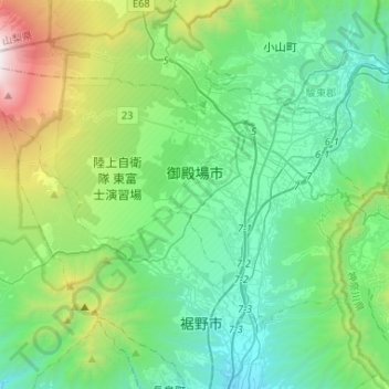
Name: Gotenba topographic map, elevation, terrain.
Location: Gotenba, Shizuoka Prefecture, Japan (35.21482 138.73169 35.36197 138.99319)
Average elevation: 792 m
Minimum elevation: 140 m
Maximum elevation: 3,054 m
Gotemba is located in far eastern Shizuoka Prefecture at an altitude of 250–600 metres (820–1,970 ft). Mount Fuji is located to the west, and Mount Hakone to the east, with the Tanzawa Mountains to the north and Mount Ashitaka to the south. The area is noted for its numerous golf courses, with the Mitsui Sumitomo Visa Taiheiyo Masters taking place annually.
Other topographic maps
Click on a map to view its topography, its elevation and its terrain.
Mount Fuji
Japan > Sunto County > Oyama
Mount Fuji, Oyama, Sunto County, Shizuoka Prefecture, Chubu Region, Japan
Average elevation: 3,261 m
Lake Sanaru
Lake Sanaru, Hamamatsu, Shizuoka Prefecture, Chubu Region, Japan
Average elevation: 16 m
Motoyama
Motoyama, Nagaoka County, Kochi Prefecture, 781-3601, Japan
Average elevation: 679 m
Setouchi
Setouchi, Oshima County, Kagoshima Prefecture, Japan
Average elevation: 26 m
Higashishirakawa
Higashishirakawa, Kamo County, Gifu Prefecture, Chubu Region, 509-1392, Japan
Average elevation: 658 m
Nishikigaoka-chuo Park
Nishikigaoka-chuo Park, Nishikigaoka 2-chome, Aoba Ward, Sendai, Miyagi Prefecture, Japan
Average elevation: 197 m
Katsura Imperial Villa
Katsura Imperial Villa, Road No. 142, Katsura-Kasugacho, Nishikyo Ward, Kyoto, Kyoto Prefecture, 615-8013, Japan
Average elevation: 25 m