
Arosa topographic map
Interactive map
Click on the map to display elevation.
About this map
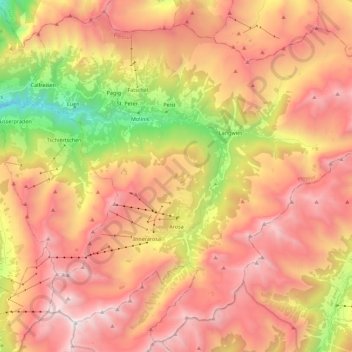
Name: Arosa topographic map, elevation, terrain.
Location: Arosa, Plessur, Grisons, Switzerland (46.72958 9.58322 46.87360 9.80700)
Average elevation: 1,985 m
Minimum elevation: 694 m
Maximum elevation: 2,959 m
Before 2017, the municipality was in the Schanfigg sub-district of the Plessur district, after that date it was part of the Plessur Region. Located on the south-east slope of the Weisshorn chain, the town of Arosa is at the top of the Schanfigg valley at the foot of the Aroser Weisshorn (2,653 m (8,704 ft)). Adjoining are the areas of Innerarosa, Dorf-Obersee, Untersee and Maran-Prätschli at an elevation of 1,690 and 1,950 meters (5,540 and 6,400 ft).
Other topographic maps
Click on a map to view its topography, its elevation and its terrain.