
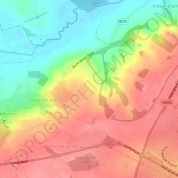
Cottingham CP topographic map
Interactive map
Click on the map to display elevation.
About this map
Name: Cottingham CP topographic map, elevation, terrain.
Average elevation: 101 m
Minimum elevation: 51 m
Maximum elevation: 139 m
Other topographic maps
Click on a map to view its topography, its elevation and its terrain.
Stanion
United Kingdom > England > Corby
Stanion, Corby, Northamptonshire, East Midlands, England, United Kingdom
Average elevation: 89 m
Rockingham Castle
United Kingdom > England > Corby
Rockingham Castle, Main Street, Rockingham CP, Corby, Northamptonshire, East Midlands, England, LE16 8TH, United Kingdom
Average elevation: 93 m