
Savaiʻi topographic map
Interactive map
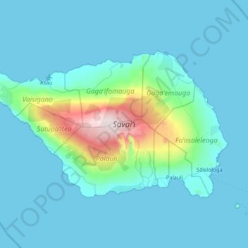
Click on the map to display elevation.
About this map
Name: Savaiʻi topographic map, elevation, terrain.
Location: Savaiʻi, Samoa (-13.80370 -172.80407 -13.43881 -172.17404)
Average elevation: 171 m
Minimum elevation: 0 m
Maximum elevation: 1,837 m
Savaiʻi is mountainous, fertile and surrounded by coral reefs. Lonely Planet describes the Savaiʻi landscape as 'spectacular tropical terrain'. The island has a gently sloping profile, reaching a maximum altitude of 1,858 metres at Mt Silisili, the highest peak in the country and the Samoa Islands chain. Volcanic craters in the highlands are strung across the central ridges from Tuasivi (literally, backbone) village in the east towards Cape Mulinuʻu to the west. The lava fields at Saleaula village on the central north coast are the result of volcanic eruptions from Mt Matavanu (1905–1911). Most of the coastline are palm fringed beaches and there are rainforests, waterfalls, caves, freshwater pools, blowholes and coral reefs. There are also numerous archaeological sites, including star mounds, fortifications and pyramids such as the Pulemelei Mound in Palauli district. Archaeology in Samoa has uncovered many pre-historic settlements including sites at Vailoa and Sapapaliʻi.
Other topographic maps
Click on a map to view its topography, its elevation and its terrain.